To help you plan your vacation, Google Maps is introducing photorealistic aerial views of roughly 100 of the world’s most iconic locations to Google Maps, including Barcelona, London, New York, San Francisco, and Tokyo.
The summertime vacation season has begun, and people are using Google Maps to plan their vacations and research business opening hours and crowdedness.
Google launched several seasonal updates for Google Maps. The first new tool is immersive view, a view that combines artificial intelligence with billions of high-resolution Street View, satellite and aerial images.
What about cyclists
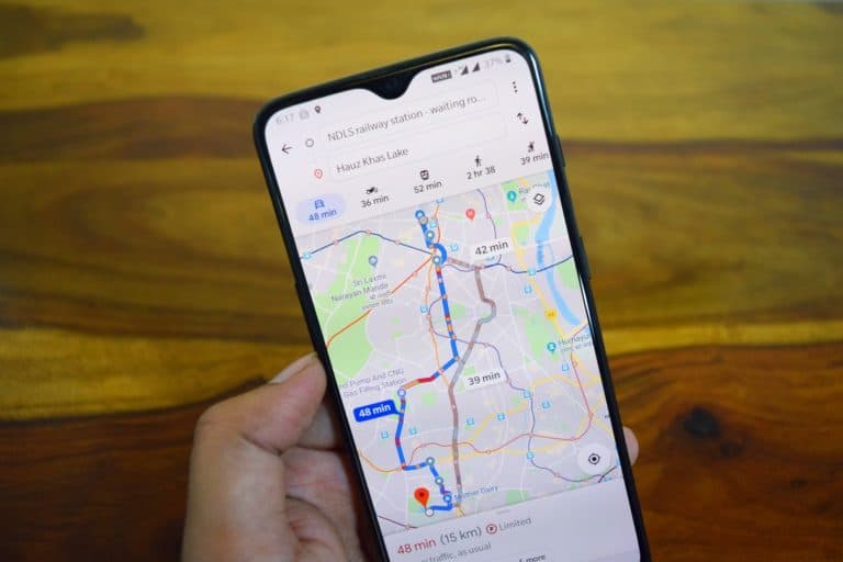
The second tool is promising for cyclists. More and more people are riding their bicycles. Cycling surged by more than 40 percent worldwide in the past few months. The new version enables route comparisons and provides granular details (when available) to help you plan for travel. After entering the directions, you’ll know if you’ll face heavy traffic, stairs, or steep slopes and the altitude along your journey.
For over a decade, Google Maps has given bike routes based on AI, city data, trustworthy cartographic sources, and input from the Google Maps community.
Location sharing
With new location-sharing alerts, you can know when friends and loved ones have arrived or departed a location, allowing you to better manage plans and have a sense of peace.
Assume you’re going to a concert with some buddies. You may set a notice for the music venue’s address if they’ve previously agreed to share their location with you, so you can know when they’ve arrived and meet up immediately. You can now set a notice to see when they leave the event in case you become separated.
To ensure your safety, Google allows you to discontinue sharing your location whenever you like.